Ryan A. Hardy, Ph.D. & Robert L. Kellogg, Ph.D.
Which way is up? It’s a seemingly simple question, but one that is fundamental to mapping our planet. Intuitively, “Up” is defined by local gravity, the opposite of the direction of plumb bob hangs. Earth’s irregular curvature means this direction changes depending on where you are. Mapping how this direction changes across Earth’s surface can yield the planet’s shape, which is a fundamental goal of the science of geodesy.
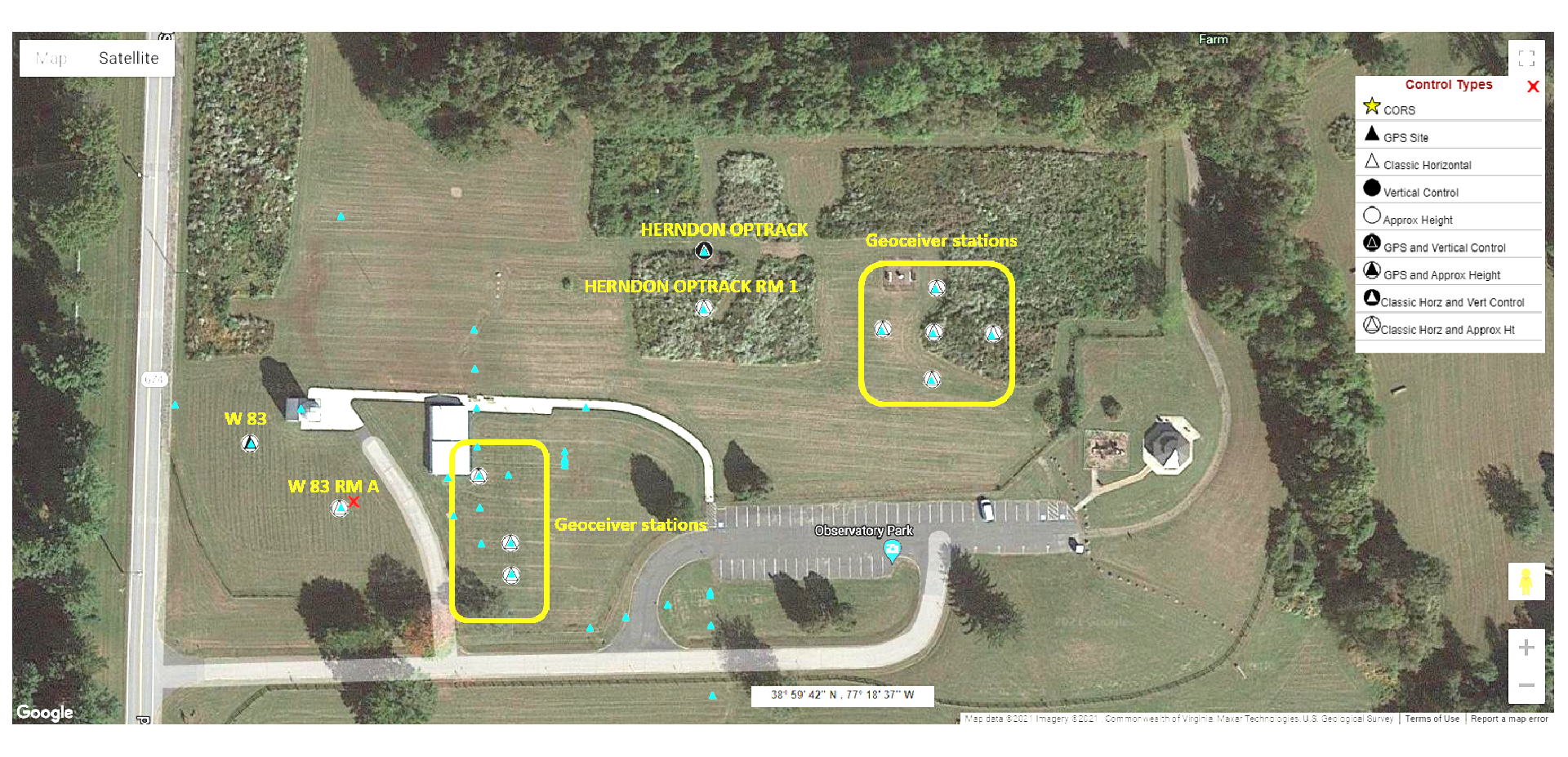
The Turner Farm Observatory Park was the site of several types of geodetic observation that contributed to the development of the global geodetic system. They played a role as reference points for observations that resulted in the creation of the reference system used for the Global Positioning System (GPS). This system enables geodetic observations that help us know where we are, understand the shape of our continents, measure sea level rise, and detect land motion from earthquakes.
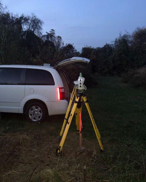
Continuing Observatory Park’s legacy as a geodetic facility, surveyors from NOAA’s National Geodetic Survey[1] visited in November 2020 to conduct astronomical observations. The purpose of this visit was to test the Total Station Astrogeodetic Control System (TSACS)[2], an instrument package that captures images of stars and returns a precise answer to the original question, “Which way is up?”
Historical geodetic measurements at Observatory Park were primarily conducted by two government offices that have gone by different names over the years. The Coast & Geodetic Survey became the National Geodetic Survey (NGS) after the creation of NOAA in 1970, while the Army Map Service (AMS) became the Defense Mapping Agency (DMA), and later the National Geospatial Intelligence Agency (NGA).
Observatory Park was once part of the W-83 Nike missile defense site for Washington, D.C. (Look for the W 83 marks in the Google Map above). The site consisted of two parcels of land: one for launch, and one for fire control. Observatory Park was part of the fire-control component, while what is now Great Falls Nike Park, a kilometer to the southwest, served as the launch site. After the decommissioning of the Nike facility in 1961, AMS transformed the site into a geodetic observing facility.
Observatory Park is among a number of sites in the Washington metropolitan area with significance to the history of geodesy. Many of these sites have historical astronomical observations that could be used to check present-day astronomical measurements made by TSACS. Many of these observations were made in the 1960s or earlier and vegetation growth rendered many of these sites unsuitable for astronomical observations. Observatory Park, with its many surviving geodetic monuments and unobstructed skies, was an ideal site for this type of observation.
What is Geodetic Astronomy?
Read more or download the attachment to see the important work done here at the Herndon Station at Turner Farm Observatory Park.
Geodetic astronomy measures the position of stars or other celestial objects to help answer two questions: “Which way is North?” and “Which way is up?” The measurements provide astronomic latitude, longitude, and azimuth, which establish how to uniquely specify the orientation of any object near Earth’s surface. By measuring these orientations, we can probe the Earth’s shape, gravity field, and rotation.[3]
Astronomic coordinates are closely related to geodetic coordinates, which specify the position of an object in 3D space. Geodetic coordinates tell you where you are using a coordinate system defined on a smooth, idealized representation of Earth known as the ellipsoid. The latitude, longitude, and height you read from a GPS receiver or map are geodetic coordinates.
For a task like navigating a ship on the open ocean, where several kilometers of position error may be tolerated, geodetic and astronomic coordinates are functionally the same. However, at finer levels of precision, local variations in gravity due to nearby masses, like mountains and ocean trenches, distort the direction of gravity from an ideal ellipsoid, often by a few arcseconds (an arcsecond is 1/3600th of a degree). We call this deviation the deflection of the vertical. This causes latitudes and longitudes measured with the stars to differ from GPS-derived coordinates by up to a few hundred meters.
The deflection of the vertical is one possible answer to the question, “Which way is up?” The variation of the deflection of the vertical across Earth’s surface traces a three-dimensional surface called the geoid.[4] The geoid is the level surface formed by Earth’s gravity that best matches mean sea level. The geoid has a wavy, irregular shape that differs from the ellipsoid by up to 100 meters. As a level surface, the geoid defines the local horizon; the direction of gravity is always perpendicular to its surface. A ball placed on a solid realization of the geoid will not roll along its slopes. In the absence of currents and winds, the oceans would precisely conform to its shape. The geoid extends under land as well as through the ocean surface. These properties make it an excellent basis for defining heights above sea level.
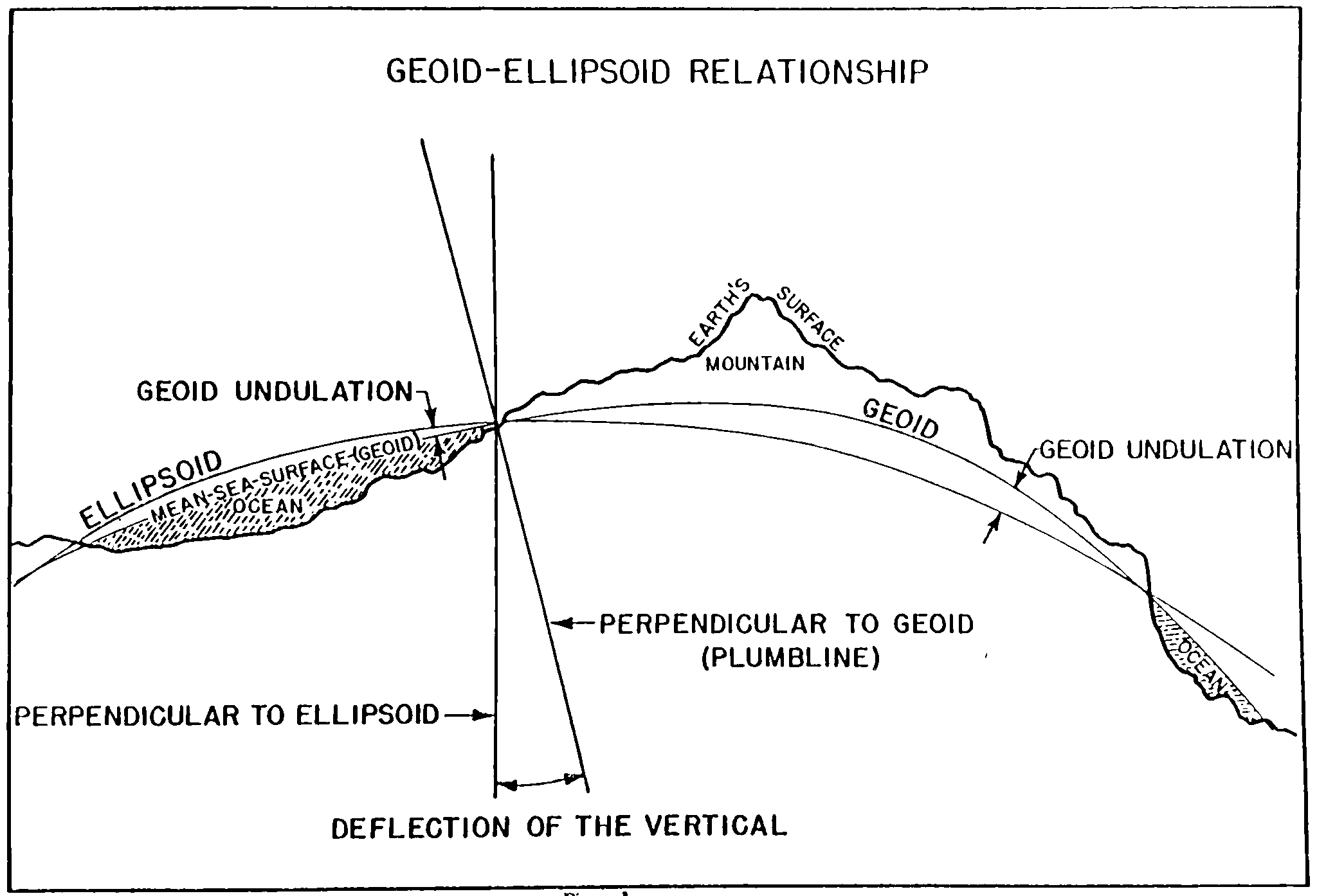
Relationship between the geoid, ellipsoid, and deflection of the vertical. From Poling (1967).[5]
The geoid model from NOAA’s National Geodetic Survey (NGS) forthcoming height system, NAPGD2022 [6] will soon define all heights in the United States.[7] This geoid model is accurate to 1 centimeter over most of the United States and will be used to convert GPS-measured heights above the ellipsoid into orthometric heights, which are heights above the geoid. Unlike with ellipsoidal heights, which are a geometric construct, water will reliably flow from higher orthometric heights to lower orthometric heights.
The deflection of the vertical is closely related to the slope of the geoid and is therefore important to geodesy. NGS and its predecessor conducted thousands of astronomical observations across North America between 1844 and 1986 to study the geoid and orient geodetic networks. [8] Geodetic astronomy was made obsolete as GPS and other space techniques matured. The geoid and deflections of the vertical could instead be predicted using models based on gravity measurements.
But today, geodetic astronomy has regained relevance. With NGS’s geoid model poised to define heights in the United States, it is important for NGS to have a number of independent techniques to measure the geoid.
In 2019, NGS began the development of TSACS, a system that performs astronomical observations with a survey instrument called a robotic total station. TSACS works by taking video of stars with the total station’s built-in telescope camera. The frames of the video stream are timestamped using a GPS time signal and are used to measure the angle between target stars and the local zenith. The vertical is established by an oil-filled cavity inside the total station, called a compensator. By measuring the vertical angles of these stars in many directions, the measurements lead to an estimate of the instrument’s astronomic latitude and longitude.
TSACS can measure the slope of the geoid from the ellipsoid to better than 1 part per million in as little as 15 minutes. This means the orthometric height difference between two points 10 kilometers apart can be discerned within 1 centimeter if their geodetic coordinates are known. Chaining astronomical measurements of the geoid slope over hundreds of kilometers allows us to reconstruct the geoid, more or less “connecting the dots”.
NGS could confirm the precision and repeatability of the instrument through testing at single sites. However, a comparison with historical measurements at multiple locations was needed to check its accuracy against established techniques. Fortunately, NGS had many options in its regional backyard, including Observatory Park.
Historical Geodetic Astronomy in the Washington Metropolitan Area
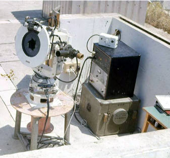
The Goddard Geophysical and Astronomical Observatory (GGAO) is a major geodetic observatory run by NASA Goddard Space Flight Center outside of Beltsville, MD. This observatory practices the four major techniques of space geodesy: very-long baseline interferometry, satellite laser ranging, global navigation satellite system (GNSS) positioning, and Doppler & Radio-Positioning Integrated by Satellite (DORIS). The data collected from these four techniques directly support the International Terrestrial Reference Frame (ITRF).[9] The Coast & Geodetic Survey observed astronomic latitude and longitude here in 1962.[10]
A kilometer to the north of GGAO lies a Department of Agriculture research facility that once hosted a Coast & Geodetic Survey satellite tracking operation. The Coast & Geodetic Survey used its BC-4 cameras to perform satellite triangulation[11] in the 1960s. This effort supported the development of one of the first global geodetic systems. Because the cameras were weather-dependent and could not compete with radio techniques, they fell out of use by the 1980s. The Coast & Geodetic Survey observed astronomic latitude and longitude here in 1966.[12]
The International Latitude Observatory in Gaithersburg, MD was part of a global network of six optical observatories that tracked the wobble of Earth’s rotational pole.[13] The observatory operated from 1899 to 1982 and was closed as radio-astronomy and satellite techniques began to provide better measurements of Earth’s rotation. The Coast & Geodetic Survey measured astronomic longitude here in 1899; and astronomic latitude in 1906 and 1911.[14] Additional astronomic positions were measured in 1968.[15]
Historical geodetic astronomy was conducted at other sites in the region, including Fort Belvoir and the US Naval Observatory. These sites were evaluated for repeat observations with TSACS, but were found to be unsuitable due to access restrictions, recent development, and vegetation growth.
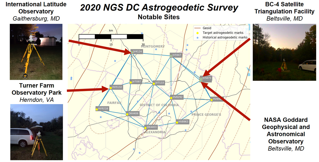
2020 NGS DC Astrogeodetic Survey Plan, including notable sites
Geodesy at Observatory Park
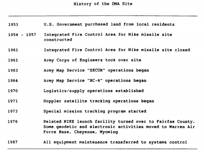
Timeline of Department of Defense operations at Observatory Park[16]
Satellite Geodesy at Great Nike Falls Park
In 1962, the Army Map Service measured the astronomic latitude and longitude of the triangulation mark BECK[17] on the grounds of what is now Great Falls Nike Park. This observation would later be compared with TSACS in 2020.
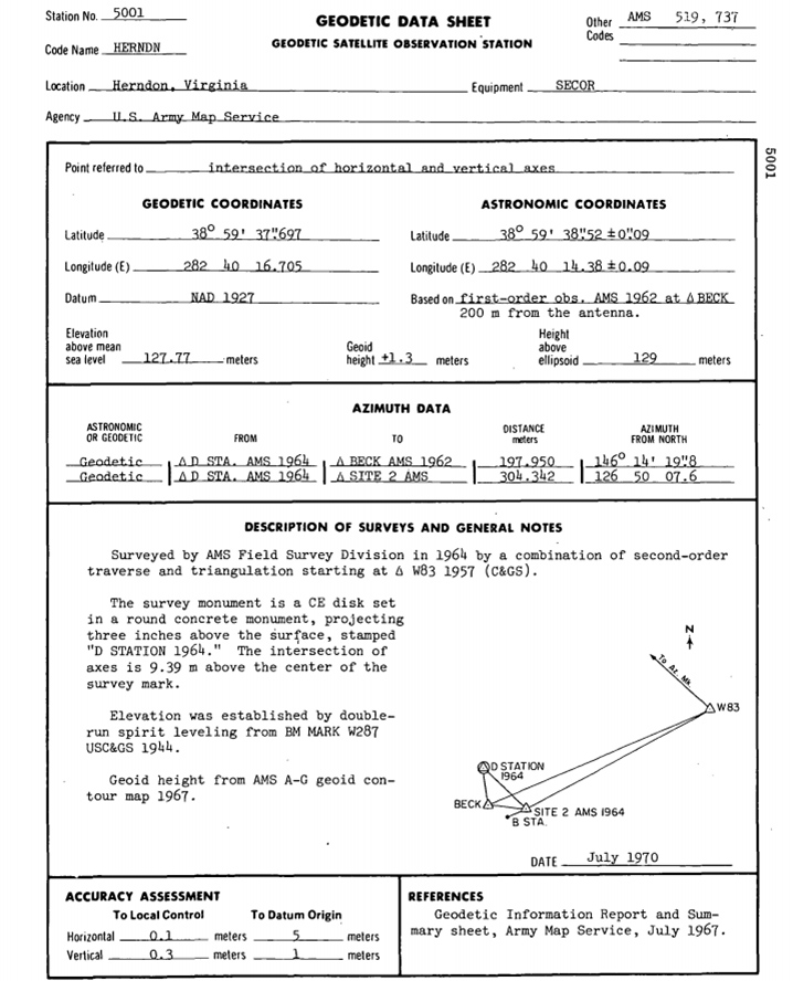
AMS installed a SECOR[18] (Sequential Collation of Range) antenna for receiving satellite signals in 1964, some 200 meters to the northwest of the BECK mark, where Forestville Elementary School now stands. SECOR was a system that measured the distance between an antenna and a satellite equipped with a transponder. By simultaneously measuring the distance to satellite from three points with known locations, the coordinates of the satellite could be established. In turn, three SECOR satellites could be used to locate an unknown terrestrial site. SECOR was used to measure the distance between Herndon and another antenna in San Diego to a precision of about 1 meter.[19]
The Air Force installed a PC-1000 camera for geodetic satellite triangulation[20] on this site, likely near the mark HERNDON CAMERA 1[21] (HV5121). Like the BC-4 cameras, these cameras photographed satellites against a background of stars to establish precise directions to these satellites. Like with SECOR, simultaneous observations of satellites from multiple sites with known positions could be used to determine the location of an observing site with an unknown position.
The western launch site was turned over to Fairfax County in 1976 and redeveloped into Great Falls Nike Park. The extent of development makes it unlikely that these marks are still present. Observatory Park, however, has a number of extant marks.
Terrestrial Geodesy at Observatory Park
Observatory Park was part of the High-precision Transcontinental Traverse[22], a Coast & Geodetic Survey project from 1961 to 1976. The Transcontinental Traverse used the best available terrestrial surveying techniques to measure the positions of thousands of sites across the United States. It leveraged an electronic rangefinder called a Geodimeter[23] and featured dense astronomic measurements for precise orientations. This project provided key terrestrial links between satellite tracking stations.
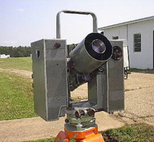
Two survey marks on the property featured in the Transcontinental Traverse: W 83[24] and HERNDON OPTRACK.[25] AMS set W 83 in 1957 and HERNDON OPTRACK in 1965. These two marks were connected to the Traverse by Geodimeter in 1966. NGS’s database shows that W 83 was used as an observing target in an astronomic azimuth observation in 1966. HERNDON OPTRACK has been used for GPS observations since the early 1990s. This mark is part of NGS’s Cooperative Base Network[26] and Height Modernization Program.[27] NGS surveyors were not able to find W 83 in 2020, but found HERNDON OPTRACK in good condition.
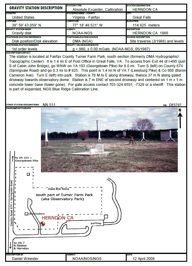
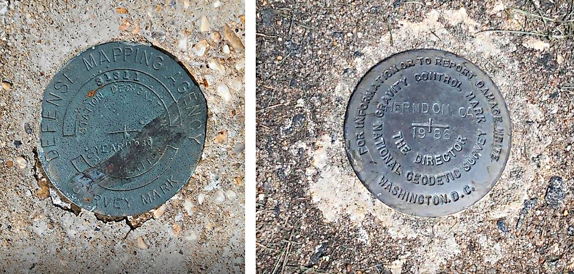
Between 1987 and 1990, absolute gravity measurements[28] were taken at the facility. These were used to extend Blue Ridge Calibration Line[29], which provided a spread of gravity values for the calibration of absolute gravimeters. The only remaining gravity mark is HERNDON CA, which NGS surveyors recovered in 2020. This mark is located some 10 meters south of the southern wall of the Roll Top Observatory.l
The next two figures below contain a description of the Herndon Gravity Station (updated 2008) and an example of a Herndon Geodetic Data Sheet of 1967 using SECOR measurements.
Satellite Geodesy at Observatory Park
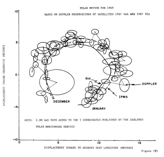
Observatory Park’s most important contribution to geodesy was its role in the Navy Navigation Satellite System (NNSS or Transit[30]). This system determined positions by measuring the Doppler frequency shift of a satellite transmitter as it passed a stationary receiver. With antenna stations of known position, the Doppler shift could be used to find the satellite’s precise orbit. Ships and submarines at sea given the satellite orbits could, in turn, use measurements of the satellite’s Doppler shift to establish their position. The Herndon DMA site was part of the tracking network (TRANET) that determined the orbits of these satellites starting in 1971.[31] The development of this system was led by Johns Hopkins Applied Physics Laboratory in Laurel, MD
Although the Navy had developed this system for submarine navigation, the technique found use in surveying and geodesy. A stationary Geoceiver[32] antenna could establish its position with an accuracy of about 1 meter after several days of Transit satellite passes. DMA installed at least 22 Geoceiver antenna monuments at Observatory Park between 1966 and 1981.[33] [34]
SECOR, Geodimeter, and Geoceiver data taken at this facility all contributed to the development of the World Geodetic System of 1972, or WGS-72.[35] WGS-72 used satellite observations to unify dozens of regional geodetic datums into a single global system. WGS-72 was later succeeded by WGS-84.
WGS-84[36] is the geodetic system to which GPS positions and most GIS datasets are now referenced. WGS-84 was initially developed from the Navy’s Doppler reference frame NSWC 9Z-2, which incorporated tracking data and position solutions from Herndon.[37] The Navy Doppler frame contributed to the initial realization of NAD 83, NGS’s present current geometric reference system for North America.[38]
Present-Day Geodesy at Observatory Park
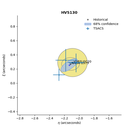
NGS tested TSACS at Observatory Park in November 2020. Before observing, the site was scouted for suitable marks. HERNDON OPTRACK was determined to be the best observation site because of its past GPS measurements and clear view of the sky. TSACS was run four times over approximately one hour and imaged 25 stars during each observation.
The resulting deflection-of-the-vertical solutions are tightly clustered, suggesting approximately 0.1 arcsecond precision for a single observation. These results neatly match both the nearby historical observation and the model predictions from NGS’s experimental deflection of the vertical model, xDEFLEC20.[39]
Projected on Earth’s surface, this precision is equivalent to about 3 meters of horizontal displacement. Vertically, this translates to a geoid slope precision of 0.5 mm per kilometer, meaning this system can be used to enable precise measurement of orthometric heights. TSACS was recently deployed in Alaska as part of NGS’s Geoid Monitoring Service [40] to gather a snapshot of the geoid and help measure how it has changed over the past century.
These new geodetic astronomy observations at Observatory Park continue the site’s legacy as a geodetic facility.
Can you find these marks near the Roll-Top Observatory?
--------------------------------------------------------------------------------------------------------------------------
[2] https://webeast.ngs.noaa.gov/web/science_edu/presentations_library/files/aguf2020_-_ryan_hardy.pdf
[3] https://geodesy.noaa.gov/PUBS_LIB/Geodesy4Layman/TR80003A.HTM#ZZ4
[4] https://www.usgs.gov/faqs/what-a-geoid-why-do-we-use-it-and-where-does-its-shape-come?qt-news_science_products=0#qt-news_science_products
[5] Poling, Arthur A.. Astronomical Azimuths for Local Control. United States, U.S. Department of Commerce, Environmental Science Services Administration, Coast and Geodetic Survey, 1967.
[6] https://geodesy.noaa.gov/datums/newdatums/index.shtml
[7] https://geodesy.noaa.gov/INFO/OnePagers/NewDatumsOnePager.pdf
[8]https://www.google.com/books/edition/North_American_Datum_of_1983/jzdZAAAAYAAJ?hl=en&gbpv=1&pg=PA39&printsec=frontcover
[9] https://www.iers.org/IERS/EN/DataProducts/ITRF/itrf.html
[10] NGS Integrated Database
[11]http://google.com/books/edition/A_New_Satellite_Tracking_System_for_Use/wLhTAAAAMAAJ?hl=en&gbpv=1&pg=PP5&printsec=frontcover
[12] NGS Integrated Database
[13] https://www.nps.gov/places/gaithersburg-latitude-observatory.htm
[14]https://www.google.com/books/edition/Astronomic_Determinations_by_United_Stat/02HoqrFCqIMC?hl=en&gbpv=1&printsec=frontcover
[15]https://www.google.com/books/edition/North_American_Datum_of_1983/jzdZAAAAYAAJ?hl=en&gbpv=1&pg=PA39&printsec=frontcover
[16] https://apps.dtic.mil/sti/citations/ADA218987
[17] National Geodetic Survey, BECK mark HV5126 Fairfax, VA. https://www.ngs.noaa.gov/cgi-bin/ds_mark.prl?PidBox=HV5126, accessed 19 Aug 2021.
[18] https://www.google.com/books/edition/Significant_Achievements_in_Satellite_Ge/lnZGAAAAYAAJ?hl=en&gbpv=1&pg=PA139&printsec=frontcover
[19] NASA, Significant Achievements in Satellite Geodesy 1958-1964. NASA SP-04, 1966 https://www.google.com/books/edition/Significant_Achievements_in_Satellite_Ge/lnZGAAAAYAAJ?hl=en&gbpv=1&pg=PA146&printsec=frontcover p. 145 accessed 19 Aug 2021. Note: this report is a who’s who of prominent scientists including William Kaula (UCLA), J.A. O’Keefe, Ann Eckels, R. K. Squires, I.G. Izak, Y. Kozai (precise orbit theory), Robert Newton (who developed the US Navy Transit Geolocation refinement algorithms), and W.H. Guier.
[20] http://google.com/books/edition/A_New_Satellite_Tracking_System_for_Use/wLhTAAAAMAAJ?hl=en&gbpv=1&pg=PP5&printsec=frontcover
[21] https://www.ngs.noaa.gov/cgi-bin/ds_mark.prl?PidBox=HV5121
[22] https://celebrating200years.noaa.gov/magazine/tct/welcome.html#intro
[23] https://celebrating200years.noaa.gov/distance_tools/aga_gm6.html
[24] https://www.ngs.noaa.gov/cgi-bin/ds_mark.prl?PidBox=HV5118
[25] https://www.ngs.noaa.gov/cgi-bin/ds_mark.prl?PidBox=HV5130
[26] https://www.ngs.noaa.gov/cgi-bin/ds_mark.prl?PidBox=HV5130
[27] https://geodesy.noaa.gov/heightmod/About.shtml
[28] https://www.ngdc.noaa.gov/mgg/gravity/1999/data/absolute/
[29] https://alt.ngs.noaa.gov/PUBS_LIB/BlueRidgeGravimeter_CBL_est_1985_TM_NOS_NGS_44.pdf
[30] https://timeandnavigation.si.edu/multimedia-asset/transit-satellite-navigation-system
[31] https://apps.dtic.mil/sti/citations/ADA181107
[32] https://americanhistory.si.edu/collections/search/object/nmah_1184131
[33] https://apps.dtic.mil/sti/citations/ADA103215
[34] NGS Integrated Database
[35] https://www.ngs.noaa.gov/PUBS_LIB/Geodesy4Layman/TR80003E.HTM
[36]/ https://apps.dtic.mil/sti/citations/ADA280358
[37] Tracking from Herndon: https://www.google.com/books/edition/Proceedings_of_the_Second_International/qY4RAQAAIAAJ?hl=en&gbpv=1&pg=PA631&printsec=frontcover&
[38] North American Datum of 1983 - Google Books

